-
 Overview
Centre Testing International Group Co., Ltd. (CTI) is a market leader in testing, inspection, certification, calibration, audit, training & technical services; building trust between governments, enterprises, and consumers.
-
 Sustainability
By building a full value chain ESG governance system covering the strategic decision-making level, management execution level and business operation level, it actively practices penetrating management of ESG risk and opportunities, empowering sustainable development across the industry chain.
-
 Our service
Centre Testing International Co., Ltd. (CTI) is the pioneer and leader in the TIC Industry which provides one-stop solutions on testing, inspection, certification, calibration, audit, training & technical services.
-
By Industry
Our service capabilties cover the upstream and downstream of the supply chain including textile and apparel,toys,electronic appliances,medical health,food...andother industries.
-
 Environment
-
 Raw Material & Fuel Chemicals
-
 Textiles, Apparel, Footwear & Accessories
-
 Food & Agricultural Products
-
 Cosmetics, Personal Care & Household Chemicals
-
 Building Materials&Construction Engineering
-
 Electronic & Electrical Appliances
-
 Toys, Furniture & Home Decoration
-
 Industrial Equipment & Manufacturing
-
 Rail & Aviation
-
 Automotive & Spare Parts
-
 Pharma and Medical Services
-
 Maritime Vessel Compliance Testing
 By Industry
Our service capabilties cover the upstream and downstream of the supply chain including textile and apparel,toys,electronic appliances,medical health,food...andother industries.
-
-
 Specialty
Comprehensively guarantee quality and safety, promote compliance and innovation, demonstrate brand competitiveness, and achieve higher quality, healthier, safer, and greener sustainable development.


-
 Management
We have established a clear governance structure in accordance with listing requirements and national regulations and policies to deal with internal and external challenges and achieve sustainable development.
-
 Information DisclosureWe are committed to establishing normal and effective two-way communication with shareholders and investors. We have established a complete information disclosure mechanism to convey information to shareholders in a timely manner.

-
 Talents Policy
Ensuring the basic rights and benefits of employees;
Providing professional skills training to promote employees’ growth;
Carrying out various kinds of activities to balance employees’ work and life.
-
 RecruitmentWelcome to join CTI family! We are providing a platform for you to show your talents and achieve your career aspiration.

QUALITY & VALUE
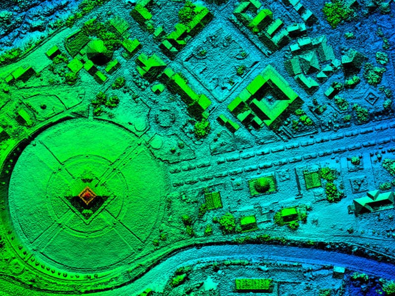
Photogrammetry and remote sensing technology has been widely used in surveying and mapping, agriculture, forestry, water conservancy, meteorology, resources and environment, urban construction, Marine, disaster prevention and mitigation and other fields. CTI provides various types of space remote sensing, aviation remote sensing and ground remote sensing services, including visible light remote sensing, infrared remote sensing, microwave remote sensing, and multi-band remote sensing.
◉ Service Background
Photogrammetry and remote sensing acquire data in a fact-based way, which is much more efficient than traditional surveying and mapping. According to the different needs of image interpretation analysis, can obtain a variety of data results, the application field is very wide. Photogrammetry and remote sensing are the general trend of the development of surveying and mapping industry. CTI adheres to the principle of "professionalism, standardization, impartiality and efficiency" to provide photogrammetry and remote sensing services for surveying and mapping, agriculture, forestry, water conservancy, meteorology, resources and environment, urban construction, ocean, disaster prevention and mitigation and other fields.
◉ Service Content
|
Domain |
Content |
|
1. agriculture |
Crop planting area monitoring, growth analysis, moisture monitoring, yield estimation; Monitoring drought, flood, hail, freezing and other disasters, farmland straw burning and fire monitoring, disease and insect pest monitoring; Remote sensing monitoring of grassland resources, remote sensing monitoring of agricultural land and monitoring of fishery resources. |
|
2. forestry |
Forest resources survey, wetland resources survey, desertification monitoring and evaluation, forestry ecological engineering monitoring, forest disaster monitoring. |
|
3.water conservancy |
Remote sensing monitoring of surface water resources, monitoring of irrigation areas, remote sensing monitoring of water distribution in rivers and lakes, ice-clearing monitoring, and flood disaster monitoring. |
|
4. Applied to the land |
Dynamic remote sensing monitoring of land use, land use change survey, basic geological remote sensing survey, geological disaster survey, mineral resources development status survey and monitoring, ecological geological environment survey. |
|
5.environmental protection |
Aerosol and particulate air quality monitoring; Remote sensing monitoring of water environment; Monitoring of human activity interference in nature reserves, environmental impact assessment of mining area development, and rural ecological environment monitoring. |
|
6.City application |
Planning and management information, intelligent infrastructure (building, pipe network digital). |
|
7.Border application |
Oil and gas pipeline monitoring, border traffic network survey, Silk Road, boundary river water resources survey. |
◉ Solution
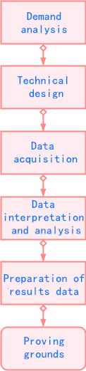
CTI provides comprehensive and complete solutions from project background, demand analysis, technical design, data processing and analysis, and results preparation.
◉ Our Strengths
High qualification: have professional Class B surveying and mapping qualification, directly docking photogrammetry and remote sensing field;
Team essence: Reasonable age structure, clear division of labor, mature experience in photogrammetry and remote sensing;
Hard quality: The company has passed several quality certifications to ensure the authenticity and reliability of data and meet the diversified needs of users;
Good service: professional technical service team, rich experience in photogrammetry and remote sensing services, ready to provide one-stop photogrammetry and remote sensing services.
◉ Service Process
◉ Q&A
1. Q: The company mainly uses unmanned aerial remote sensing or satellite space remote sensing?
A:According to the specific needs of the project, CTI will decide the remote sensing method, which is UAV aerial remote sensing or satellite aerospace remote sensing. It has a high requirement of resolution (cm). Under the condition of small scale and abundant funds, uav UAV aerial remote sensing can be selected, such as real estate surveying and mapping, 3D modeling, etc. If the resolution level is in meters and the scale is relatively large, satellite remote sensing will be selected, such as national-level and provincial-level coastline monitoring, reclamation survey, county-level and city-level crop category monitoring, and large-scale disaster assessment, etc.
2. Q: Does the company have a confidentiality mechanism?
A:CTI has the surveying and mapping Grade B qualification, and shall establish and improve the confidentiality system to ensure the safety of surveying and mapping results in accordance with relevant national laws and regulations on confidentiality and surveying and mapping geographic information. Conduct confidentiality training for all employees of the company and sign confidentiality agreements.
3. Q: Whether the company has sound after - sale measures?
A:The company has a professional after-sales process, set up a special after-sales staff for each project, regularly visit customers, help customers to solve problems; We promise to respond to the problem within 12 hours and solve the problem within 24 hours after receiving feedback from users.
◉ Cooperation Case
Basic Information Data Collection Project of Jianchang County Real Estate Unified Registration Platform (rural collective construction Land).
Dalian Jinpu New Area reclamation project.
Cadastral surveying and mapping project of Bengang.
Yingkou Port Xianren Island port area cargo train loading and unloading reclamation acceptance project.
Reclamation and acceptance project of iron and steel (profile) storage yard in Xianrendao Port area, Yingkou Port.
-
 Engineering SurveyingEngineering survey is an important part of project construction, it can improve the overall quality of the project, go smoothly, p...More
 -
 Real Estate Surveying and MappingReal estate surveying and mapping is widely used in cadastral survey and cadastral database construction, real estate surveying an...More
 -
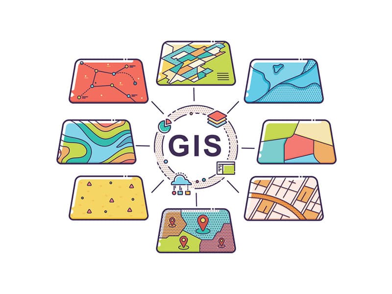 Geographic Information EngineeringGeographic Information System (GIS) is widely used in land, surveying and mapping, planning, water conservancy, geology, public se...More
Integrity statement | Privacy Policy | Global service network | Complain/Report | Declaration Statement | Website map | General Terms and Conditions Copyright Centre Testing International All rights reserved
 粤公网安备 44030602000441号